2026-09-07 · for Miro, and for the readers of verticalsigns and seg3d · branch t3code/build-dem-bias-rejection · written in ASD-STE100 Simplified Technical English
Summary
The handoff document gave two tasks. First, tablecloth must make one ground surface for each segment. Before, it made one surface for each drive pass. Second, the new method must not pull the ground surface down.
Both tasks are complete. The new default is ground_scope=segment with segment_seed_combiner=mode. In each cell of 0.2 m the program collects the lowest point of each drive pass. It puts these values into groups. Two values are in the same group if the difference is less than 0.10 m. The program then selects the largest group. If two groups have the same size, the program selects the higher group. The median value of the selected group becomes the seed.
In one cell the records can see more than one real surface. The min rule always takes the lowest of them. The mode rule takes the surface that most records see. On the open road this is correct and it corrects the DEM. Below vegetation it is not correct: there most records see only the top of the plants. Section 3 gives the numbers.
Warning — do not adopt this default yet
The gate keeps every point below the ground model. A model that is too high therefore makes vegetation into ground.
Measured on the ground-truth points that are more than 1 m below the median of the records (154,789 points): min keeps 0.952 of them, mode keeps 0.9999. The mode combiner does not find these points. Its model is above them.
No metric on this page measures the height error of the ground model below vegetation. The DEM-bias metric needs 3 or more ground-truth ground points in a cell. Such cells are on open ground.
Correction of 2026-09-08: section 1 previously gave a wrong cause ("ghost returns"). The cause is the order statistic. The measured results do not change.
removedthe seed combiners mode and mode_ref. They are on the branch archive/segment-seed-combiners-do-not-merge, which must not be merged.
pooled SMRFsegment scope is now: pool every record, one seed raster, unchanged SMRF. ground_percentile is the only seed knob.
+0.79 mmedian height error of the surface below vegetation. One surface for each record gives +3.77 m, mode gives +4.01 m.
−1,089lines of code removed. 207 tests become 181, and all pass.
identicalsegment 018 under the new default gives 7 mask files byte-identical to the old min option.
verified If you set --set ground_scope=record, the output is identical to the seg3d reference of 2026-09-05 for segment 018. This applies to the masks, the overlays and the cleaned npz files.
not done The branch is not pushed. There is no Jira tag. The directory ground_A1B0 is not made again. The three acceptance tests of verticalsigns are not done.
Look at the cost before you use the new default. In a forest, no drive pass sees the ground below the trees. Thus the shared surface follows the top of the trees. The program then keeps the trees as ground. Section 3 shows this. The old method also had this problem, but less frequently (0.84 against 0.99).
0 · Words used in this report
record
One drive pass along the segment. One npz file contains one record. A segment has 6 to 8 records.
segment
A part of the road, approximately 100 m long.
cell
A square of 0.2 m × 0.2 m in the horizontal plane.
seed
The first estimate of the ground height in one cell.
surface
The model of the ground. The SMRF filter calculates it from the seeds.
gate
The test that keeps a point as ground: z − surface ≤ 0.05 + 1.25 × gradient. The test has no lower limit. Thus the program keeps all points below the surface as ground.
ghost return
A false point below the true ground. A reflection from a wet or smooth surface causes it. The false point is a mirror image of an object above the road.
record scope
The old method. The program makes one surface for each record.
segment scope
The new method. The program makes one surface for each segment.
combiner
The rule that selects one seed from the lowest points of all records in one cell.
GT
Ground truth. A person gave a class to 1,872,942 points in segment 085.
DEM bias
The height of the surface minus the height of the true ground. A negative value shows that the surface is too low.
recall
The fraction of the true ground points that the program keeps as ground. A high value is good.
leak
The fraction of a class (for example trees) that the program keeps as ground. A low value is good.
1 · The problem: the minimum of K records is biased low
Correction of 2026-09-08
An earlier version of this page said that the low points are "ghost returns", that is, false points below the ground. That statement is wrong. Miro rejected it, and the human ground truth confirms that he is right.
The low points are real surfaces. The old test compared them with the median of the records. Where most records see only the top of the vegetation, that median is in the vegetation. Real ground then looks like an error.
The correct test uses the human ground truth of segment 085. Each point gets the label of the ground-truth point within 5 cm. This table shows what the person labelled the points that create the union minimum:
label of the human
points
share
median depth below the median of the records
road
48,278
0.684
−3.47 m
not labelled
13,537
0.192
−2.87 m
tree
7,341
0.104
−5.00 m
medium vegetation
1,345
0.019
−2.22 m
low vegetation
96
0.001
−8.33 m
Source: render/gt_test_lowpoints.py. 70,618 points in the area that the human mapped. More than two thirds are road. They are a lower carriageway, and ground below trees and below an embankment. They are not artefacts.
The real cause is the order statistic. This table shows each order statistic of the record minima minus the height of the human road, on the 101,783 cells of segment 085 that have 3 or more ground-truth ground points:
statistic of the record minima
p5 (m)
p50 (m)
fraction more than 0.05 m too low
fraction more than 0.30 m too low
lowest record (this is min)
−0.221
−0.015
0.308
0.027
second lowest record
−0.111
−0.009
0.137
0.006
third lowest record
−0.058
−0.005
0.058
0.001
median of the records
−0.042
−0.004
0.042
0.001
Source: render/gt_road_bias.py. Each step up the order removes approximately one half of the low tail. This is the behaviour of the minimum of K values that contain noise. There is no separate population of noise. The remaining error is a few centimetres for each point. It is not visible in a rendering.
Result. In a cell, the records can see more than one real surface: the carriageway, a lower carriageway, and the ground below vegetation. The min rule always takes the lowest surface. The SMRF filter then puts the ground model at that lowest surface. The true carriageway is then more than 5 cm above the model, and the gate removes it. This is why the road recall decreases from 0.915 to 0.794.
2 · What ships, and what was rejected
What ships. Segment scope pools every record, makes one seed raster with the per-cell minimum, then runs the unchanged SMRF and the unchanged gate. The minimum over the pooled points equals the minimum of the per-record minima, so this is exactly the old min option without any machinery. Segment 018 under the new default gives 7 mask files that are byte-identical to the old min run.
What was rejected. The mode combiner put the record minima into groups and used the largest group. Its purpose was to reject "ghost returns". Section 1 shows that those points are real surfaces, so the purpose was invalid. The code is preserved on the branch archive/segment-seed-combiners-do-not-merge. Do not merge that branch.
The one seed knob.ground_percentile replaces the strict minimum with a percentile of the pooled points. On the open road a higher percentile is better. Below vegetation it is much worse, because there the ground is the lowest few per cent of the returns. Section 3 gives the numbers. Keep the value at 0.0.
The measurements below were made before the deletion. They stay in this report because they are the evidence for the decision.
DEM bias against the human ground truth of segment 085
How to read these plots
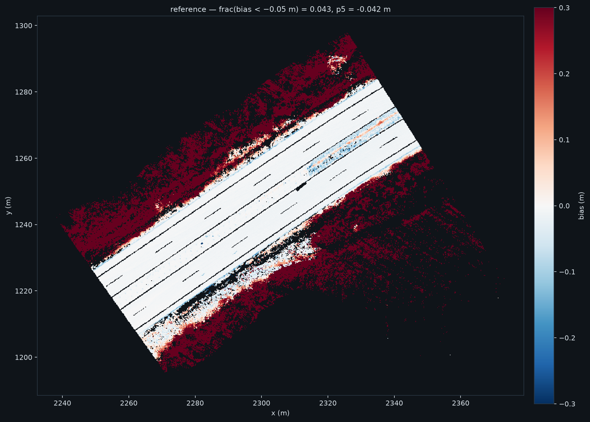
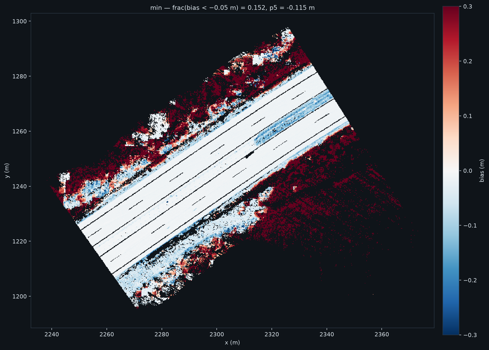
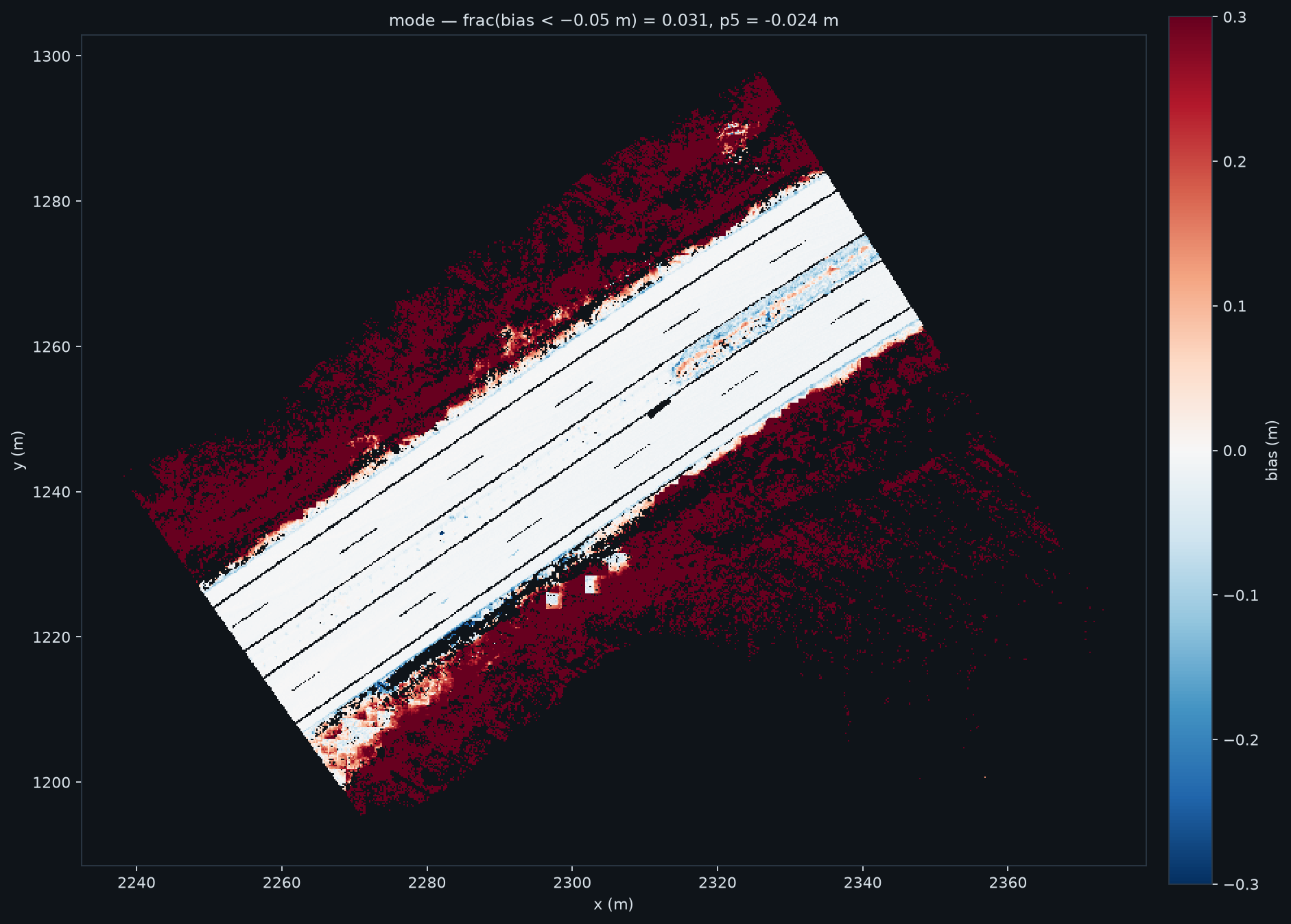
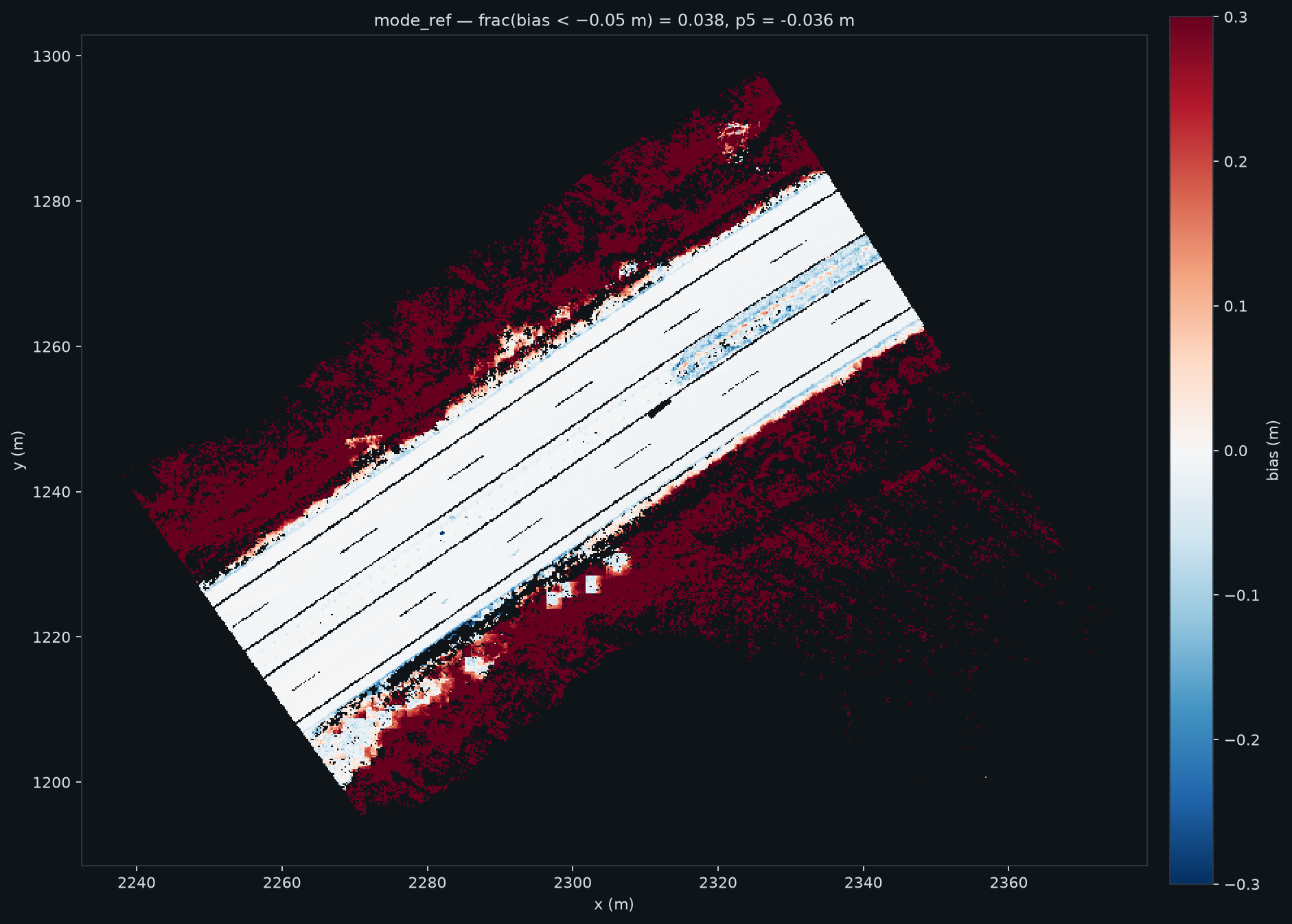
The four maps: the axes are the coordinates x and y in metres. Each pixel is one cell that has 3 or more true ground points. The colour is the surface height minus the true ground height. Blue = the surface is too low. Red = the surface is too high. White = correct. All four maps use the same colour scale.
What to compare: look at the second map (simple minimum). Large blue areas cover the carriageway. In the third map (mode) these areas are white.
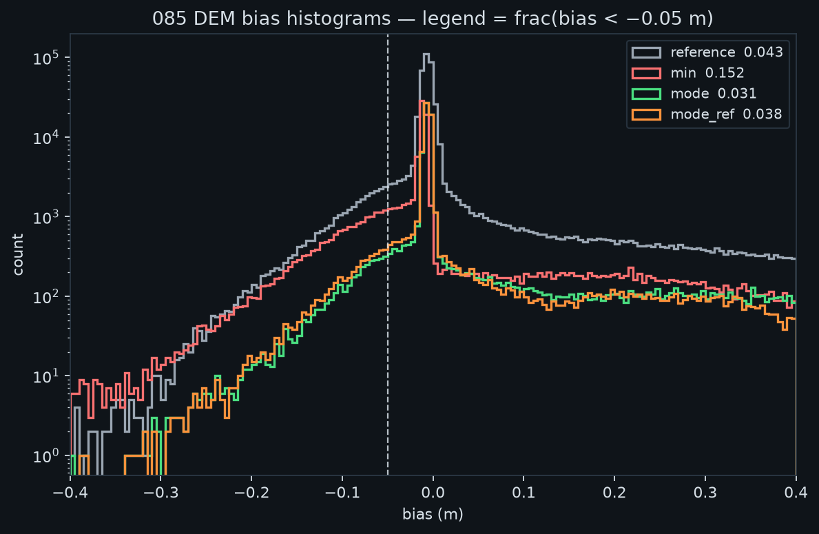
Histogram: the horizontal axis is the DEM bias in metres. The vertical axis is the number of cells, on a logarithmic scale. The dashed line is at −0.05 m, which is the limit of the gate. Cells to the left of the dashed line cause the loss of true ground points. A good curve is narrow and near 0.
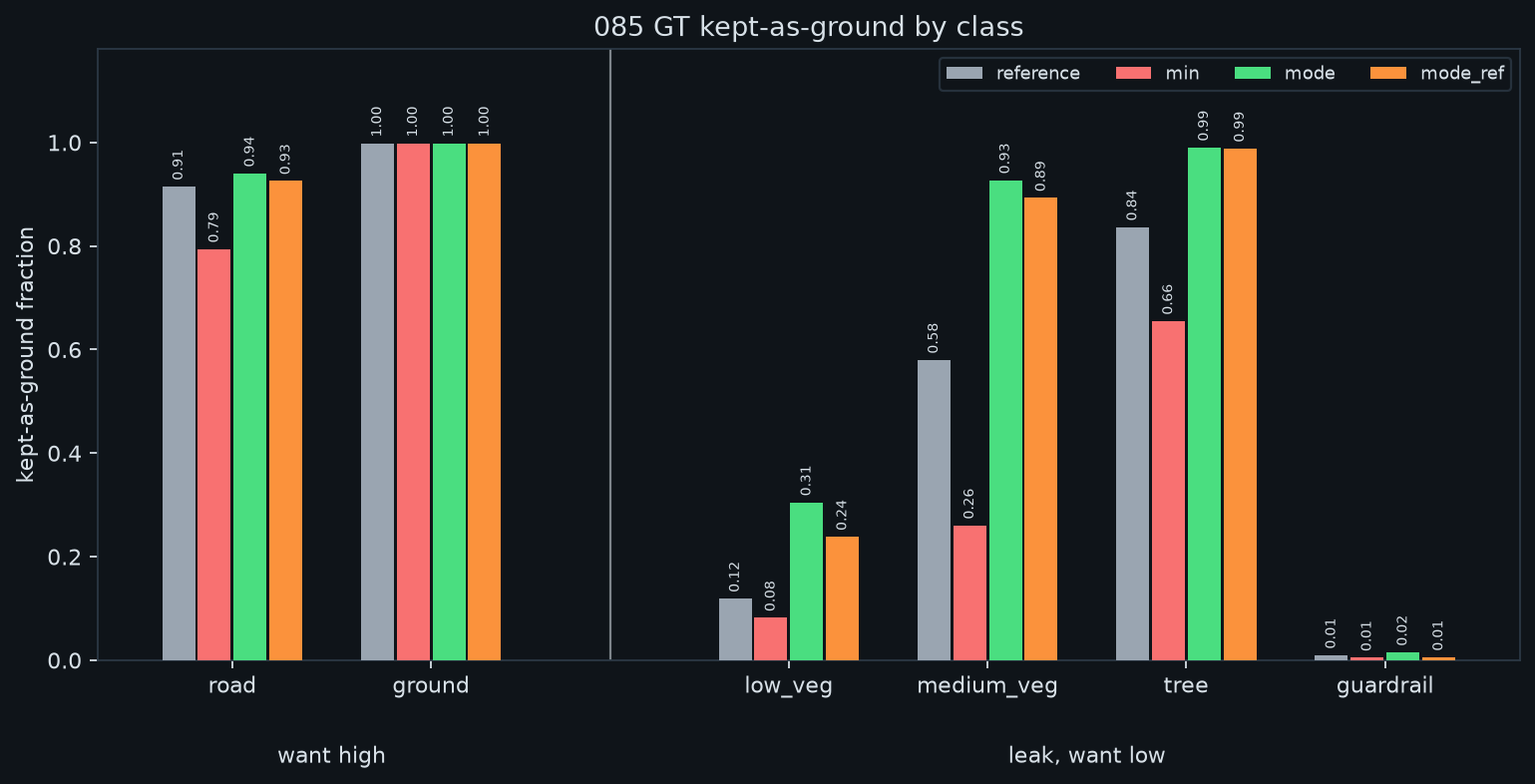
Bar chart: each group of bars is one class of the ground truth. The height is the fraction of that class that the program keeps as ground. The bars for road and ground must be high. The bars for vegetation and objects must be low.
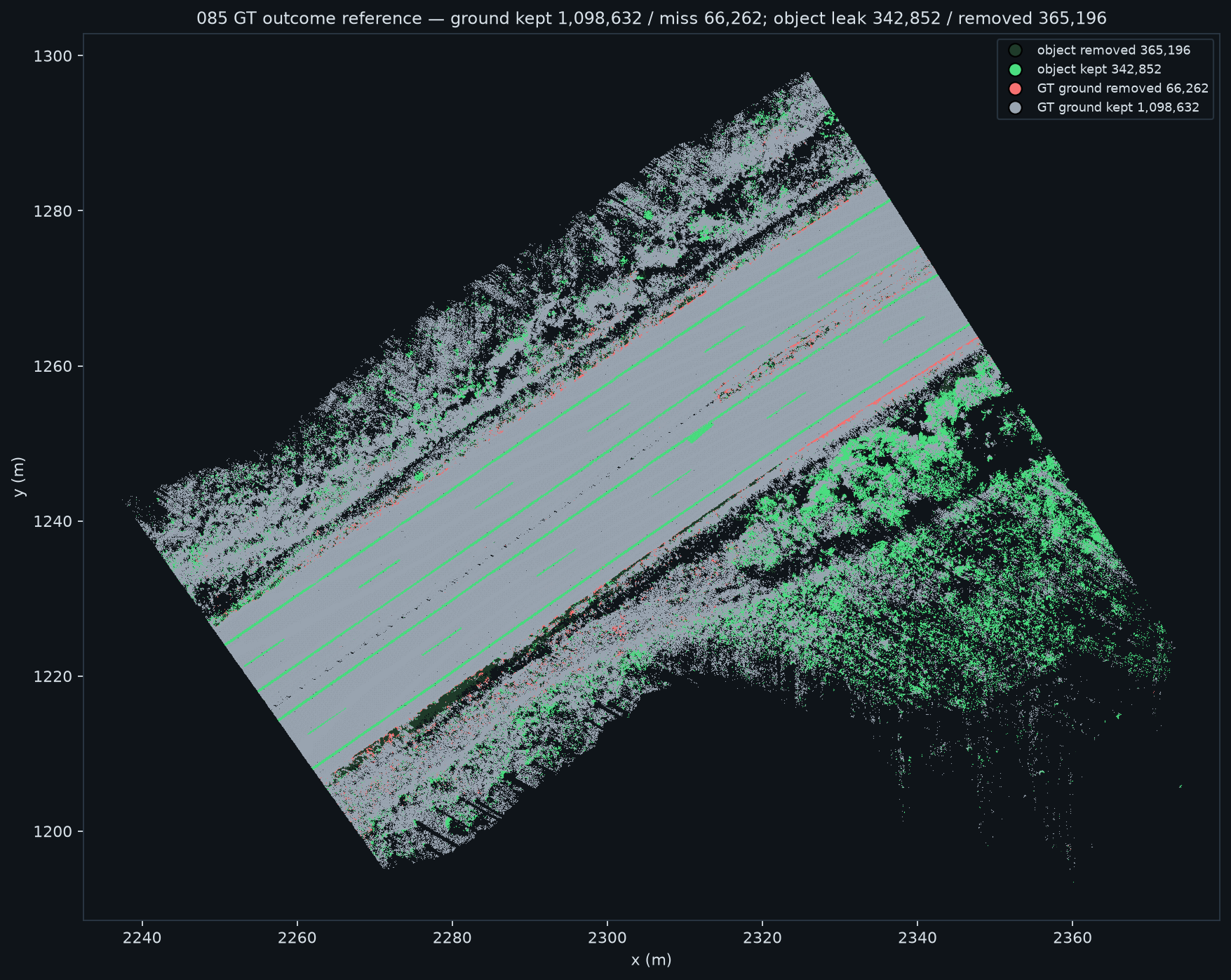
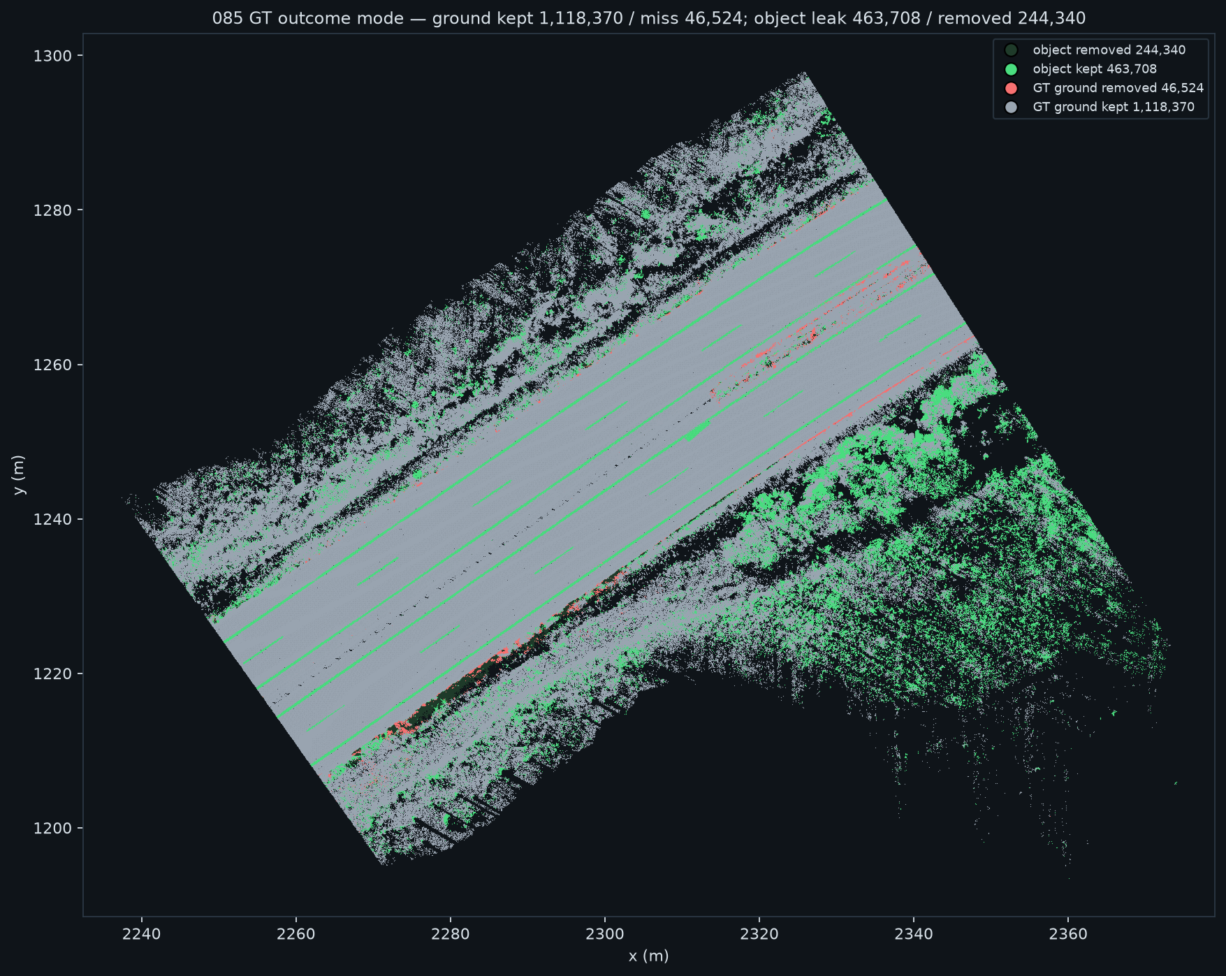
The two outcome maps: each point is a ground-truth point. Red = a ground point that the program did not keep (an error). Green = an object point that the program kept (also an error). Grey = correct. Fewer coloured points is better.
one surface for each record (the old default)one surface for each segment, simple minimumone surface for each segment, mode combiner (the new default)mode_ref variant (optional; drop 0.50 m, agreement of 2 records)
histogram of the DEM bias; the dashed line is the limit of the gatefraction of each ground-truth class that the program keeps as groundresult for each ground-truth point, one surface for each recordresult for each ground-truth point, mode combiner
combiner
bias, 5th percentile (m)
fraction more than 0.05 m too low
road recall
ground recall
low vegetation leak
medium vegetation leak
tree leak
guardrail leak
one surface for each record
−0.042
0.043
0.915
0.998
0.119
0.580
0.837
0.010
simple minimum
−0.115
0.152
0.794
0.999
0.082
0.260
0.655
0.005
mode (new default)
−0.024
0.031
0.941
0.999
0.305
0.927
0.991
0.016
mode_ref (optional)
−0.036
0.038
0.926
0.999
0.238
0.893
0.988
0.006
How to read the table. The first four columns show the quality of the ground surface. Lower values in columns 2 and 3 are better. Higher values in columns 4 and 5 are better. The last four columns show the errors. Lower values are better. Source: diag/combiner_harness_v5_085.md. In that file, mode has the name mode_med, and mode_ref has the name mode_desc_0.50_s2.
The tree leak is high for all methods. The gate has no lower limit, thus the program keeps all points below the surface. In a forest the surface is at the top of the trees, because no record sees the ground. The old method already had a tree leak of 0.837.
3 · The real problem: the surface below vegetation
The gate has no lower limit. Every point below the ground model becomes ground. A model that is too high therefore makes vegetation into ground. Until 2026-09-08 no measurement looked at the height of the model below vegetation. This is that measurement. It uses the 6,436 cells of segment 085 where the human labelled ground points and also vegetation more than 0.5 m above them.
seed rule
below vegetation, median error
more than 1 m too high
open ground, more than 0.05 m too low
one surface for each record (production today)
+3.77 m
0.918
0.040
pooled minimum (the new default)
+0.79 m
0.458
0.146
pooled percentile 1
+1.09 m
0.525
0.115
pooled percentile 5
+2.21 m
0.827
0.078
pooled percentile 25
+5.17 m
0.904
0.039
mode combiner (rejected)
+4.01 m
0.925
0.034
Source: render/gt_veg_surface_error.py. Every percentile above 0 lifts the model into the canopy. Keep ground_percentile at 0.0.
The gate decides, not the seed. The pooled minimum is below the road more often than a per-record surface is, and a gate of 0.05 m is too narrow to absorb that. This table uses the pooled-minimum surface on segment 085 and changes only max_elev_diff_m:
gate (m)
road
ground
low vegetation
medium vegetation
tree
guardrail
0.05
0.794
0.998
0.082
0.260
0.655
0.005
0.10
0.873
0.999
0.170
0.339
0.672
0.013
0.15
0.929
1.000
0.317
0.423
0.689
0.021
0.20
0.962
1.000
0.489
0.502
0.707
0.034
Source: render/gt_gate_sweep.py. Compare the line for 0.15 with the production values today (one surface for each record, gate 0.05): road 0.915, medium vegetation 0.580, trees 0.837, low vegetation 0.119, guardrail 0.010. A gate of 0.15 m is better on the road, on medium vegetation and on trees. It is worse on low vegetation and on guardrails. A wider gate keeps more object points as ground. Do the verticalsigns sign test before you change it. The gate is unchanged in the code.
Why the model is too high below vegetation
Most drive passes see only the top of a bush. Usually only one pass has the correct angle to see the ground below the bush. The mode combiner uses the majority, thus the surface stays at the top of the bush. The program then keeps the full bush as ground.
The old method gave the correct result for the one pass that saw the ground, and the incorrect result for the other passes. For this reason its medium-vegetation leak was already 0.580.
combiner
recall, all ground-truth ground
recall, ground more than 1 m below the median of the records
min
0.863
0.952
mode
0.960
0.9999
mode_ref
0.950
0.9999
Source: render/gt_lowroad_recall.py, segment 085, 1,164,894 ground-truth ground points, of which 154,789 are more than 1 m below the median of the record minima. The mode combiner keeps almost all of them because its model is above them. The same effect keeps the vegetation.
The mode_ref variant can move the seed down to a lower group, if 2 or more records agree. This decreases the leak, but it also decreases the accuracy of the ground surface. A larger permitted movement admits the ghost returns again. Thus mode_ref is optional and is not the default.
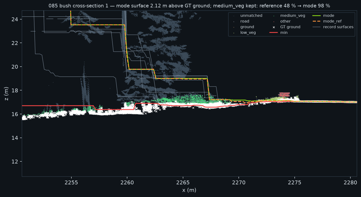
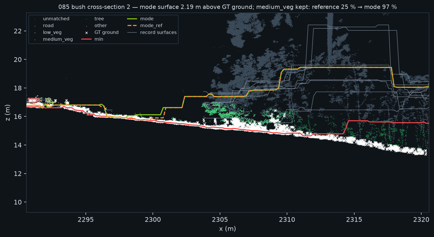
Vertical sections where the surface follows a hedge
How to read these plots
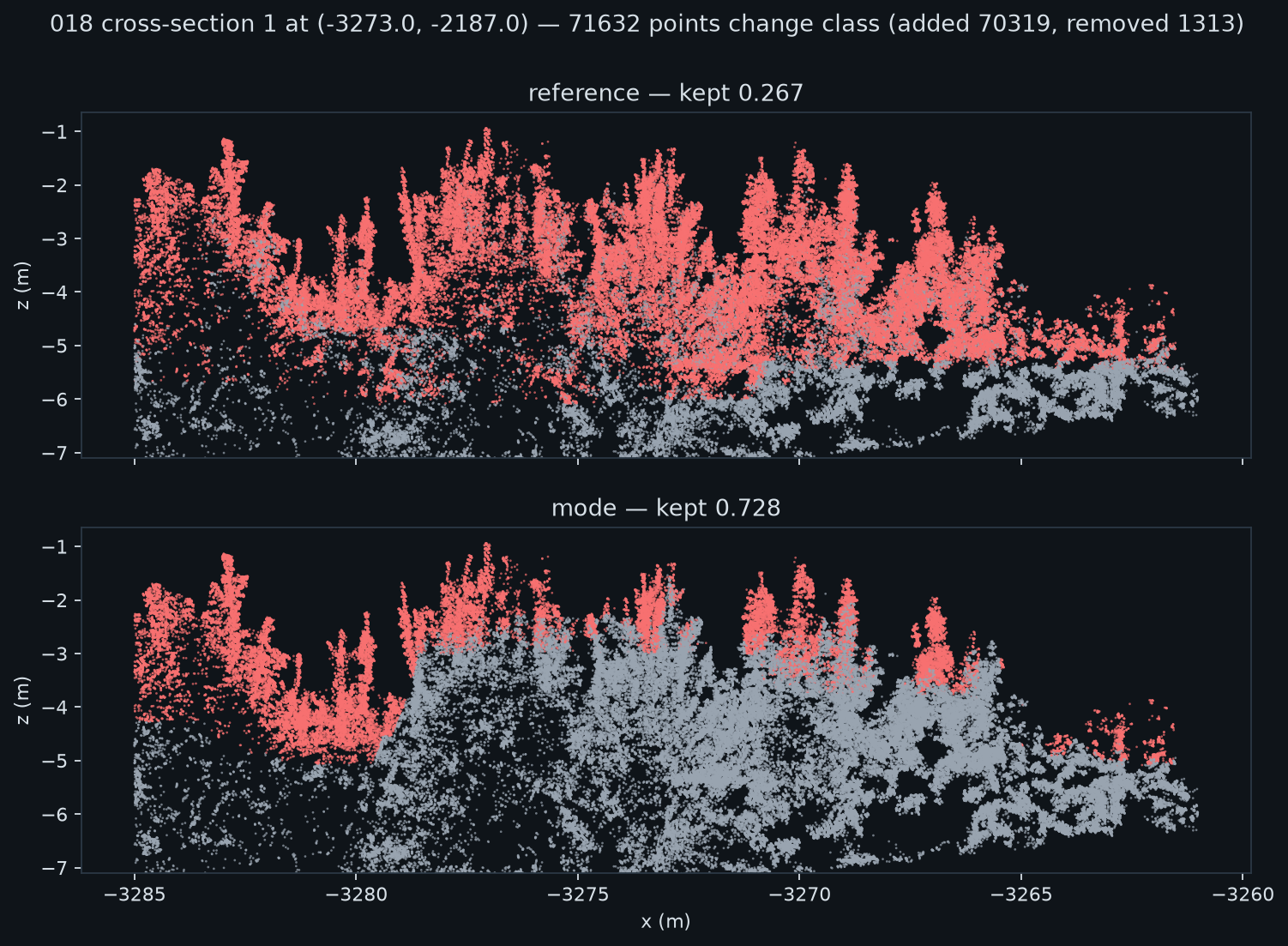
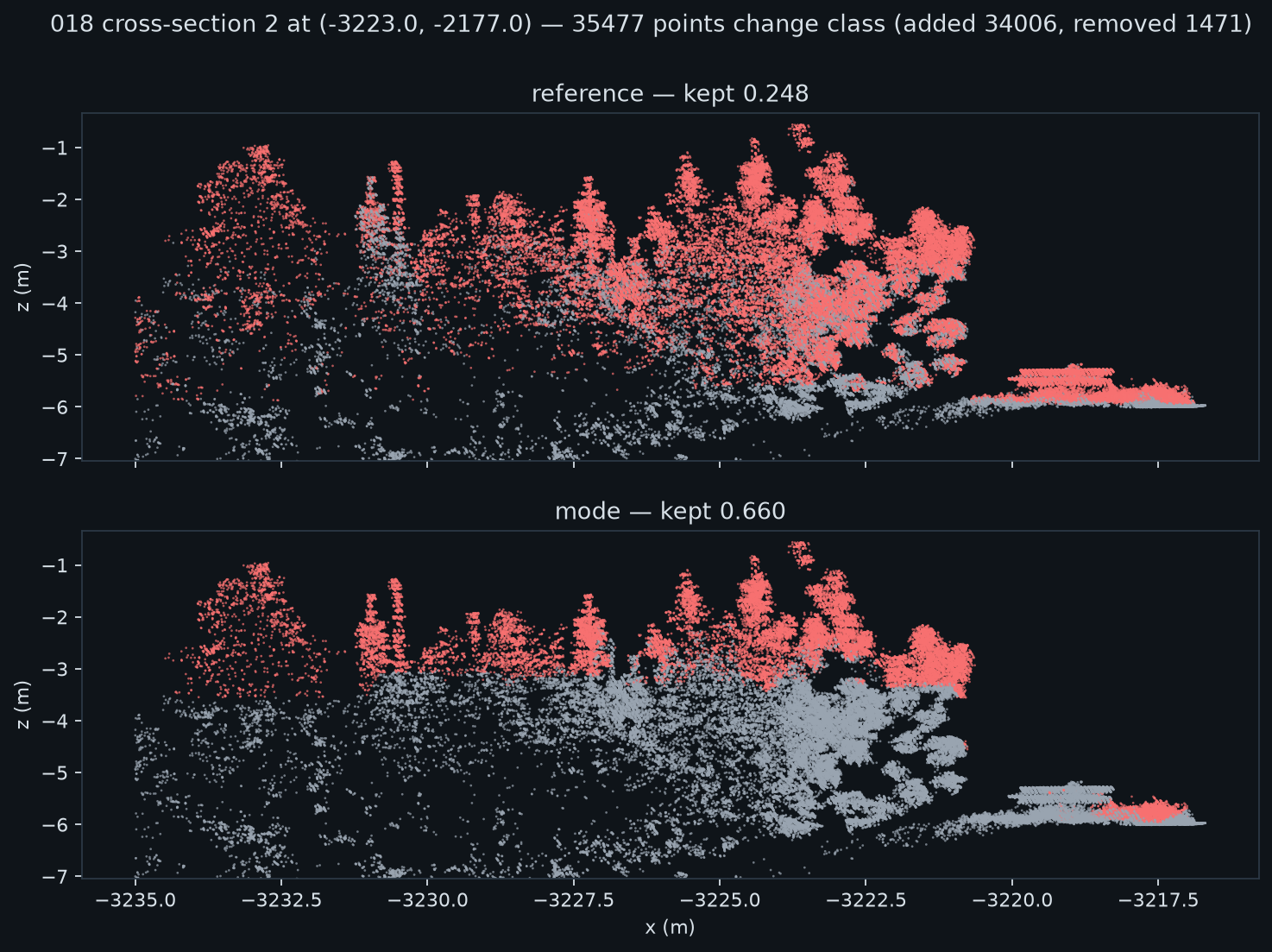
All four plots: the horizontal axis is the distance along the section in metres. The vertical axis is the height in metres.
Plots 1 and 2 (segment 085): the colour of each point is its ground-truth class. The lines are the surfaces, as in section 1: red = simple minimum, green = mode, grey = one record.
Plots 3 and 4 (segment 018): the upper panel shows the old method, and the lower panel shows the mode combiner. The colour shows if the program keeps the point as ground.
Result to see: the green line is above the true ground and inside the vegetation. All points below the green line become ground points. This is the cost of the correction.
segment 085, hedge section 1segment 085, hedge section 2segment 018, the cell with the largest change: old method above, mode below. The frame is cut at z = -7 m, so the ground is not in it. All visible points are vegetation.segment 018, the cell with the second-largest change
In the forest beside the road all methods put the surface at the top of the trees. The grey lines of the single records are also 3 m to 7 m above the true ground. No record sees the ground, thus the filter fills these cells from the road. The mode combiner uses the majority, thus it does this more frequently. In the hedge of segment 018 the program keeps the vegetation up to 3 m above the ground. The kept fraction in that section increases from 0.27 to 0.73. This is the meaning of the increase of the tree leak from 0.837 to 0.991.
Where the classification changes
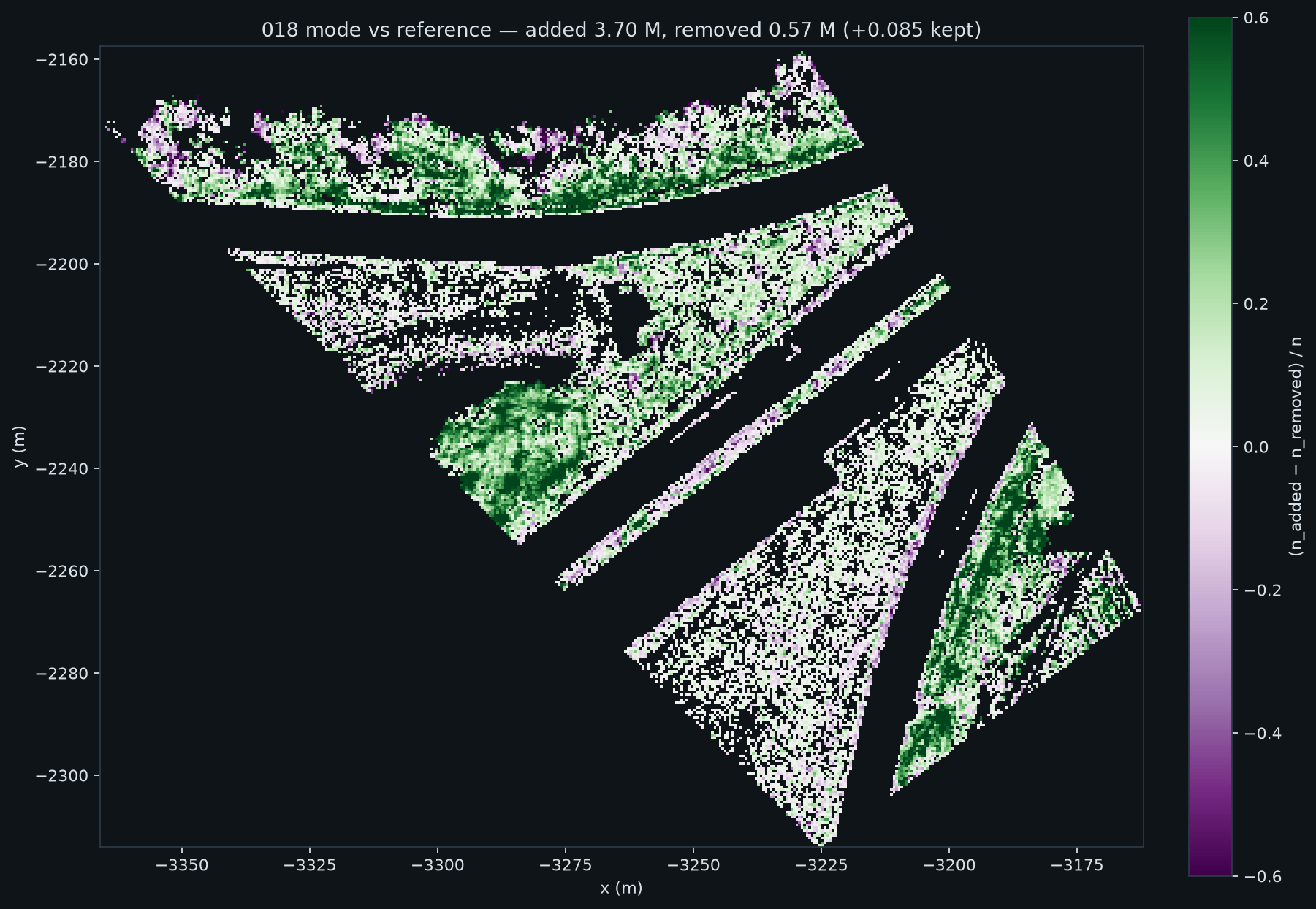
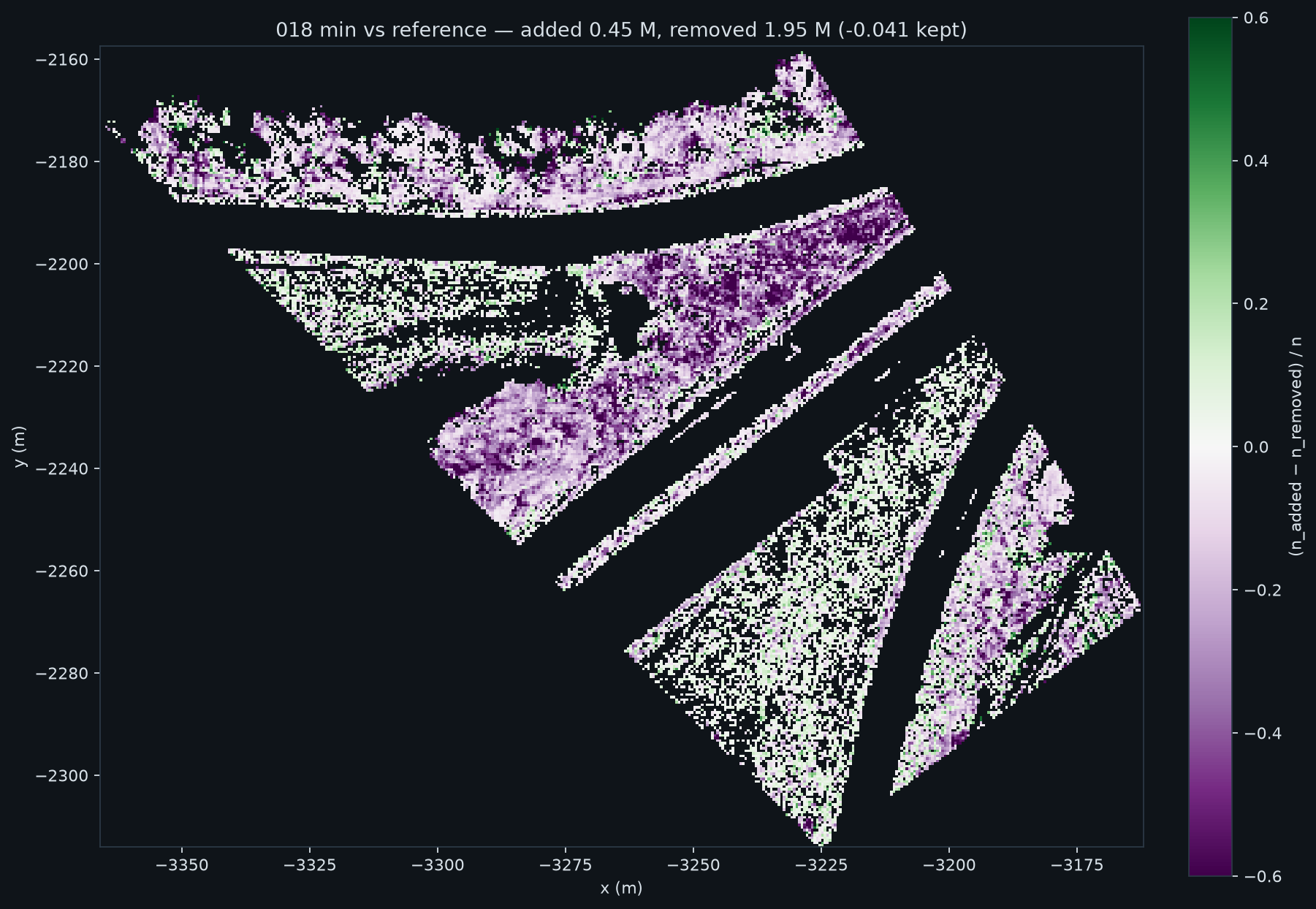
How to read these plots
Both maps: the axes are the coordinates x and y in metres. Each pixel is a cell of 0.5 m.
Green = the new method keeps more points as ground.Purple = the new method keeps fewer points as ground. Black = no change.
Result to see: in the first map the green areas are along the vegetation at the side of the road. The carriageway does not change. In the second map (simple minimum) large purple areas cover the carriageway. This is the error that section 1 shows.
segment 018: mode combiner against the old methodsegment 018: simple minimum against the old method
For segment 018, the mode combiner adds 3.70 million points and removes 0.57 million points. The kept fraction increases by 0.085. The added points are in a small number of cells that contain dense vegetation. The largest cell, at x = −3273 and y = −2187, gains 38,700 points. For segment 086 the kept fraction increases from 0.625 to 0.668.
4 · Full views of segment 018
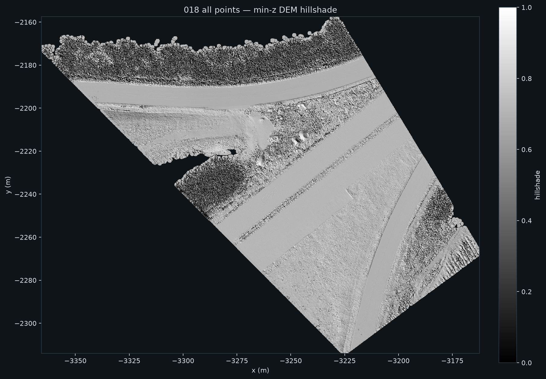
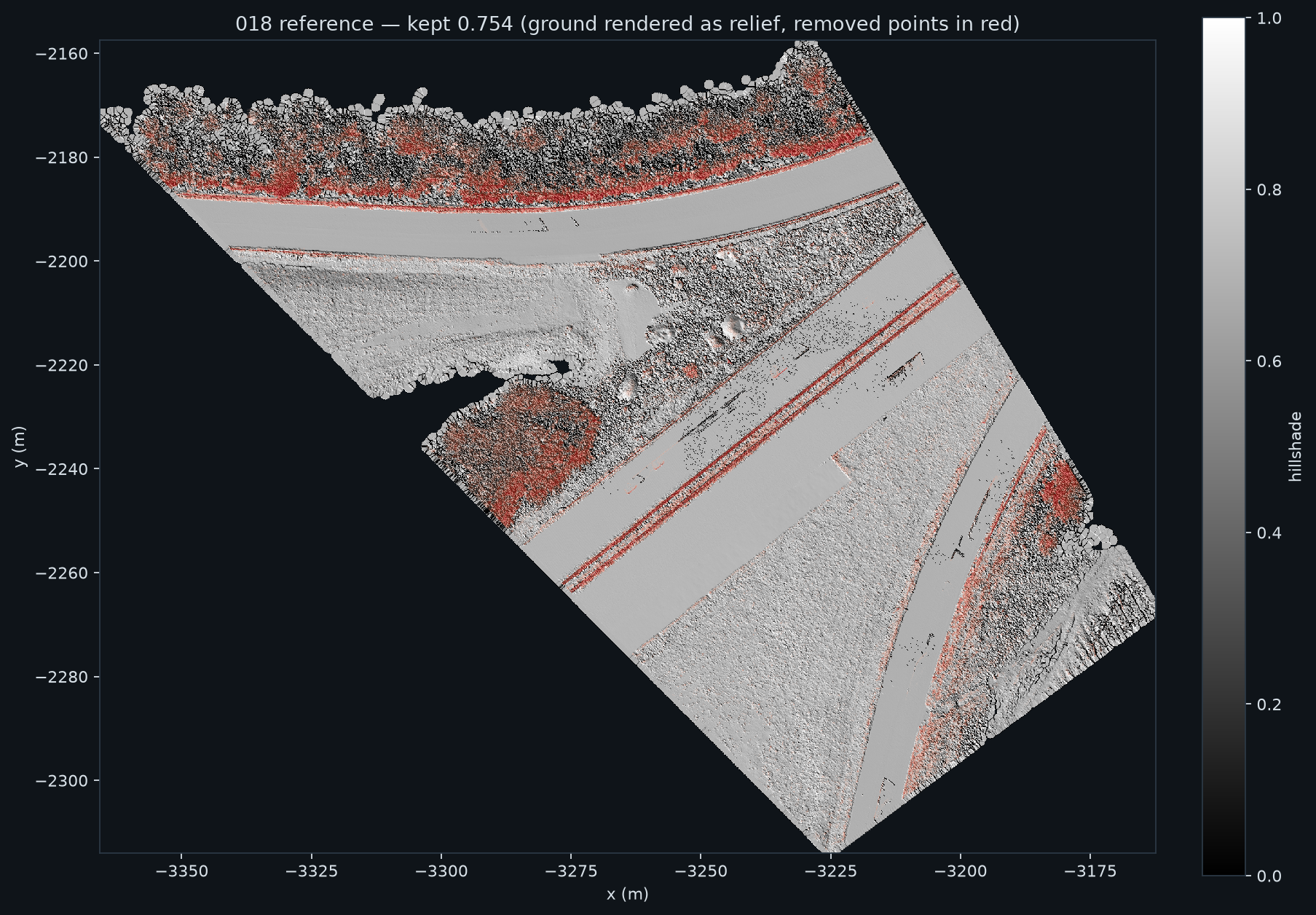
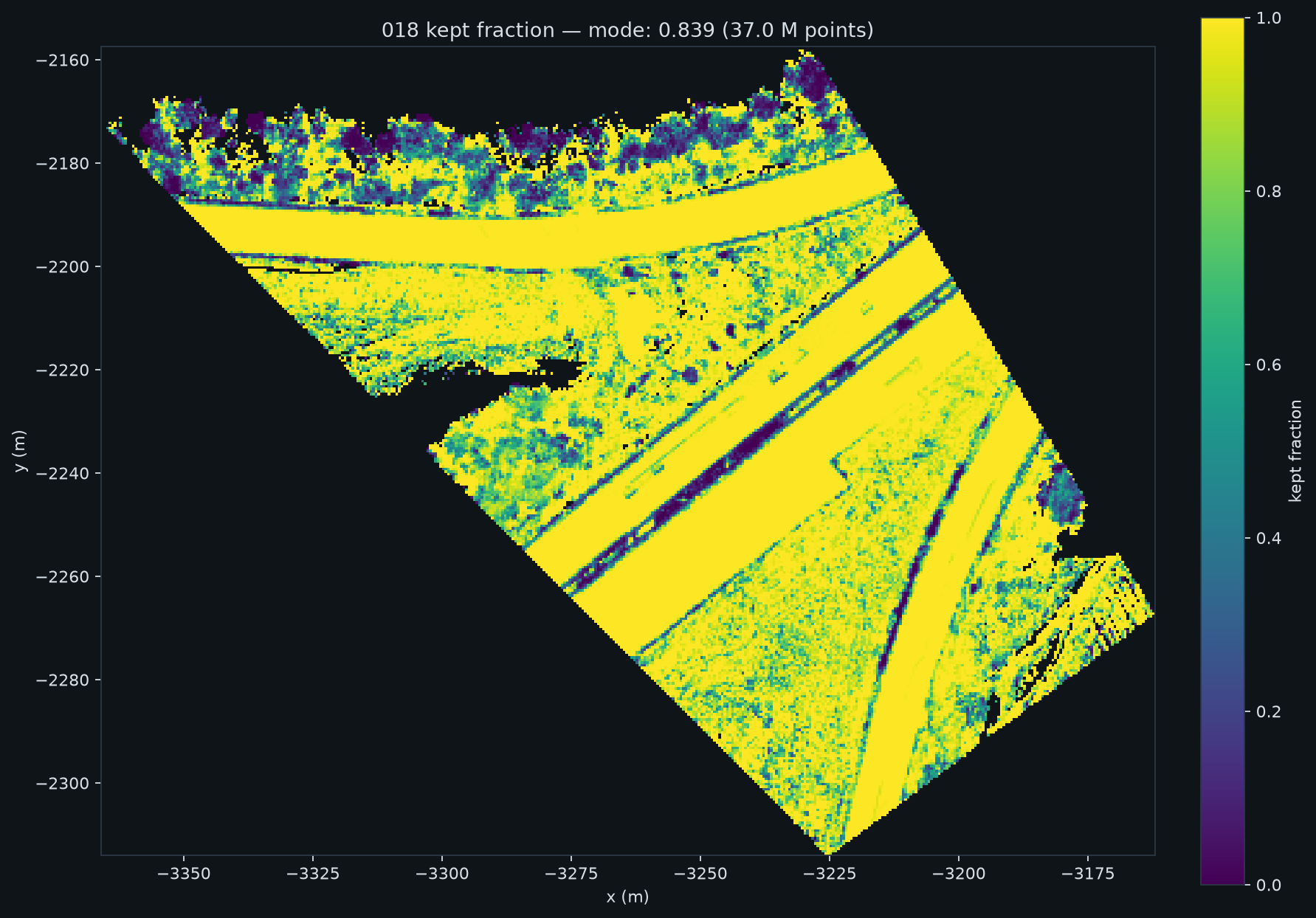
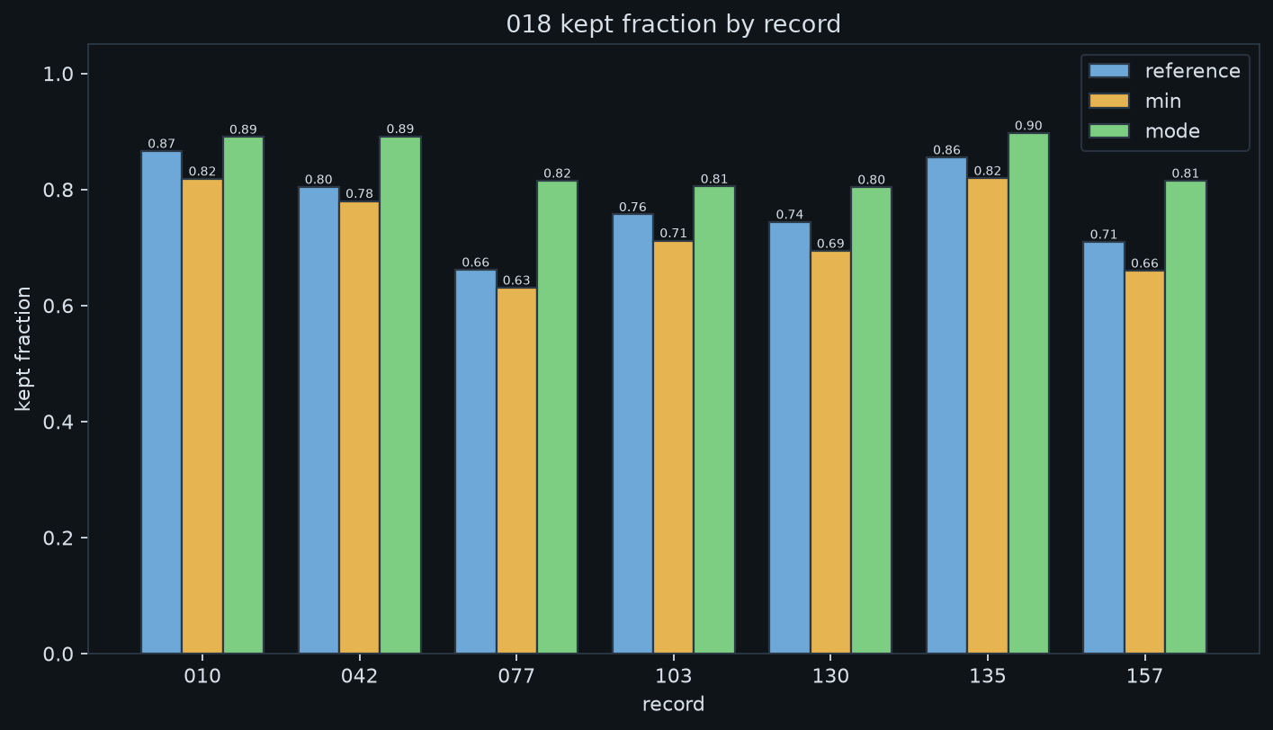
Segment 018: 7 records, 37.0 million points
How to read these plots
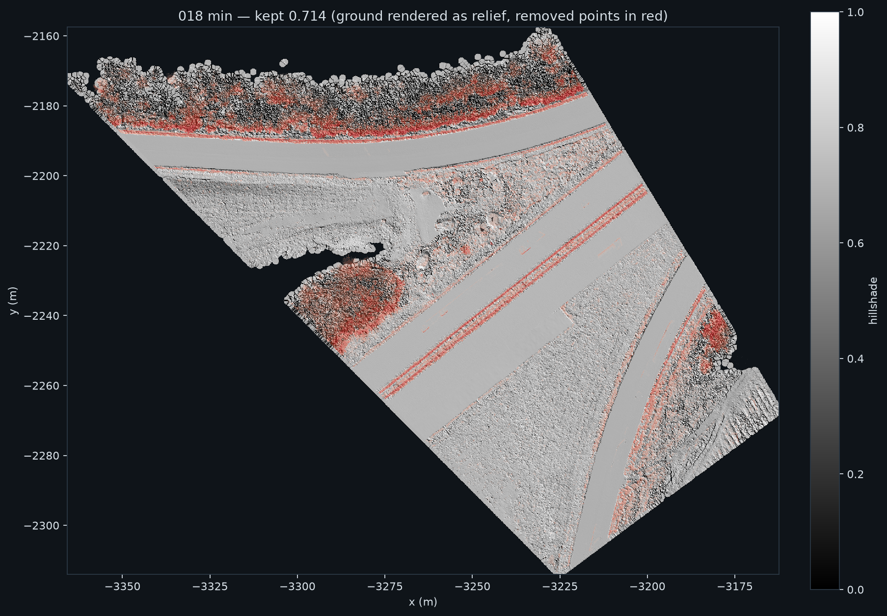
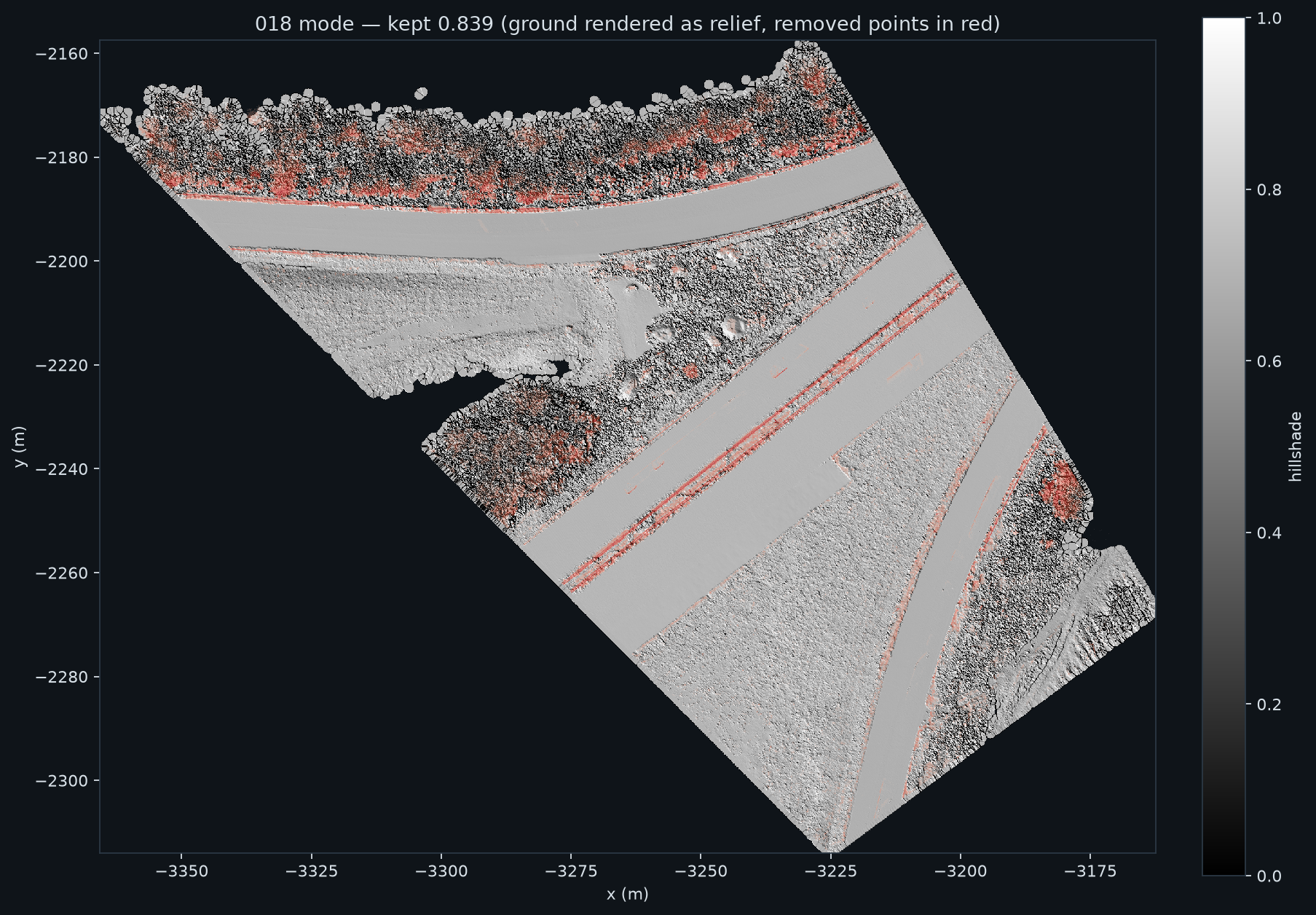
The four views in the first row: the axes are the coordinates x and y in metres. The grey image is a shaded relief of the points that the program keeps as ground. The cell size is 0.1 m. Red areas are the points that the program removes.
What to compare: in the view of the simple minimum the carriageway has more red. This shows the loss of true road points. In the view of the mode combiner the carriageway is grey again.
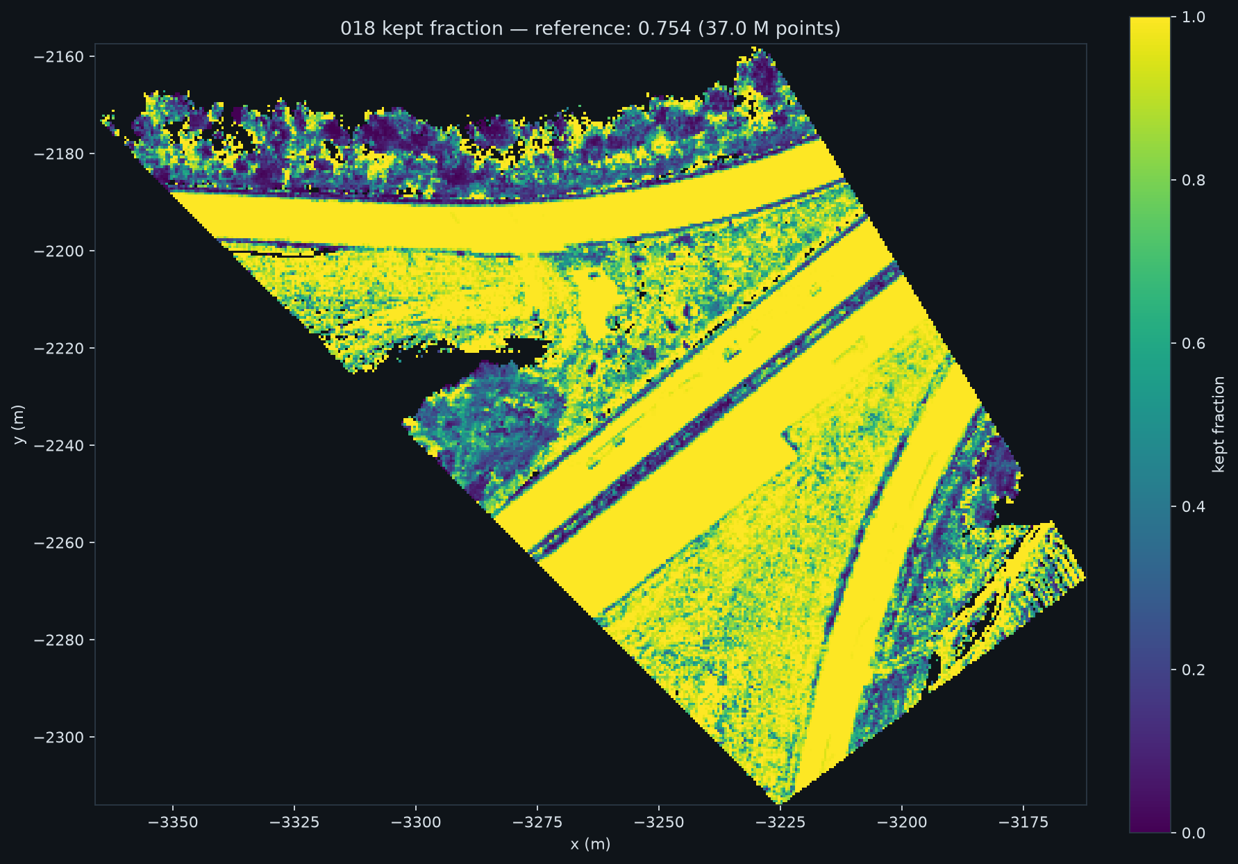
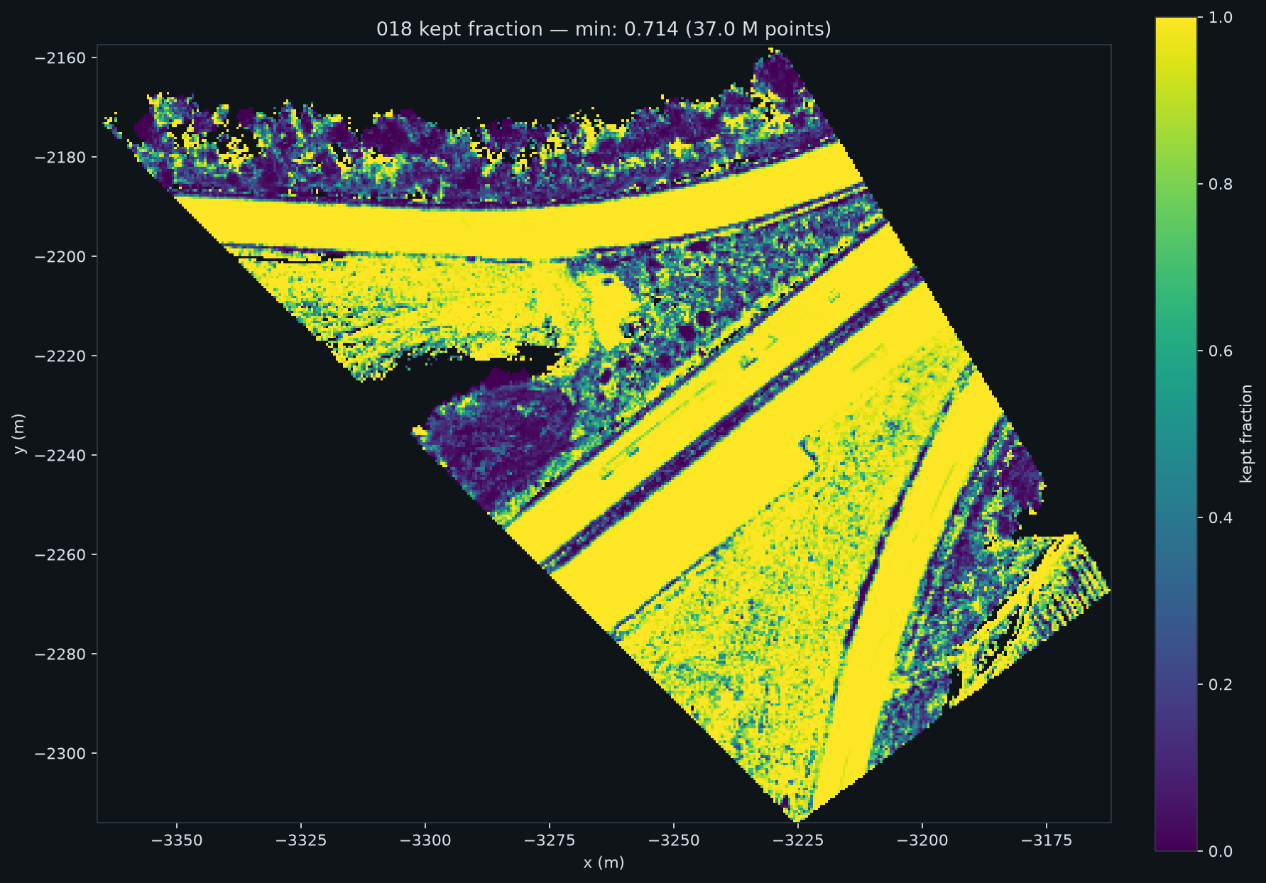
The three maps in the second row: the colour is the fraction of points that the program keeps as ground in each cell of 0.5 m. A bright colour means a high fraction.
The bar chart: one bar for each record. The height is the kept fraction of that record. Compare the bars of the three methods. No bar of the mode combiner is lower than the bar of the old method.
all points, for comparisonone surface for each record (old method)one surface for each segment, simple minimumone surface for each segment, mode combiner
kept fraction, old methodkept fraction, simple minimumkept fraction, mode combinerkept fraction of each record
5 · Numbers for each segment
segment
records
points
kept, old method
kept, simple minimum
kept, mode
worst record, simple minimum
worst record, mode
surface difference, 5th percentile
018
7
37.0 M
0.754
0.714
0.839
−0.050
+0.024
−0.47 m
060
6
31.5 M
0.668
0.614
0.709
−0.064
+0.027
−0.37 m
085
8
47.8 M
0.604
0.511
0.637
−0.108
+0.014
−2.06 m
How to read the table. "Kept" is the fraction of all points that the program classifies as ground. "Worst record" is the largest decrease of the kept fraction of one record, against the old method. Only records with 100,000 points or more are included. A negative value shows a loss. "Surface difference" is the 5th percentile of the segment surface minus the record surface. A negative value shows that the shared surface is below the surface of one record. This occurs where a record cannot see the true ground, or where the majority of the records contain ghost returns.
Segments 065 and 066 of branch 0 of A1 are not used in this report. Their data is corrupt. Source: diag/combiner_harness_v5.md. Full runs of the software: segment 018 gives 0.754 → 0.839, segment 086 gives 0.625 → 0.668 (diag/ab_default_vs_record.md).
run
time
maximum memory
remark
segment scope, segments 018, 086 and 085
149 s
0.96 GB
one surface for each segment
record scope, segments 018 and 086
234 s
1.22 GB
output identical to the seg3d files of 2026-09-05
memory limit for the seeds
records × cells × 58 bytes must stay below 25 % of memory_budget_gb. The value of 58 bytes was measured with tracemalloc.
6 · Changes to the software
Removed on 2026-09-08: segment_seed_combiner, segment_seed_link_m, segment_seed_ref_drop_m, segment_seed_min_support, ClusterStats, cluster_record_minima, combine_record_seeds, build_segment_seed_surface, the stack of per-record grids with its memory limit, and tests/test_seed_combiners.py. 1,089 lines fewer.
Added: accumulate_segment_seed_grid. It streams the records into one pooled seed grid. With ground_percentile > 0 the program uses the existing in-memory path.
Configuration: ground_scope is segment (default) or record. ground_percentile (default 0.0) is the only seed knob.
Not changed: the SMRF finalisation, the gate, the record path, and the CSF path.
Tests: 181 pass and 6 are skipped. Two tests prove that the pooled grid equals the minimum over a stack of per-record minima, and that the percentile path matches the record path.
# the new default (one pooled surface for each segment)
uv run python -m iolabs_point_cloud_tablecloth.runner --data-dir <lane_points> --segments 018,085 --out <out>
# the old behaviour, identical to the files of 2026-09-05
uv run python -m iolabs_point_cloud_tablecloth.runner ... --set ground_scope=record
7 · Your decisions
Set max_elev_diff_m. This is now the decision that matters. 0.05 keeps the vegetation low but loses road points. 0.15 is better than production on the road, on medium vegetation and on trees. Section 3 has the table.
Do the three acceptance tests of verticalsigns before any change of the gate. (a) The kept fraction of each segment must stay within ±0.05 of the old value. (b) The road sign in segment 018 at x = −3212.87 and y = −2195.74 must stay in the point cloud. (c) The ground height must not decrease more than 0.5 m at the reference positions, and the tree crowns must not get holes. A wider gate makes test (b) more difficult.
Keep ground_percentile at 0.0 until a new measurement says something else.
Jira tag, push of the working branch, release to Nexus. None of these is done. The archive branch is pushed.
Make the directory ground_A1B0 again only after the acceptance tests.
More data
The methods that were tested and rejected
Diagnosis (diag/minz_diag.md): the records have no height offset. The ghost returns make dense groups. Their number increases with the number of records.
Test method 1 and 2: a comparison of the kept fraction against the old method is a weak test, because the old method also keeps ghost returns. Thus the human ground truth of segment 085 was used.
Lowest value with agreement (2 or more records, with different bin sizes): ghost returns occur in more than one record, thus they get the agreement. The road recall stays at 0.86 to 0.88.
Median of all values: the bias becomes 0.032 and the road recall 0.941. But the kept fraction of some records decreases by 0.03. The mode combiner does not have this effect.
mode_ref, first version: it could select a group above the mode. The second version permits only groups below the mode.
Permitted movement of 0.30, 0.50, 1.00 and 2.00 m: each larger value decreases the leak and also decreases the accuracy of the surface. No value is better than mode for the ground surface.